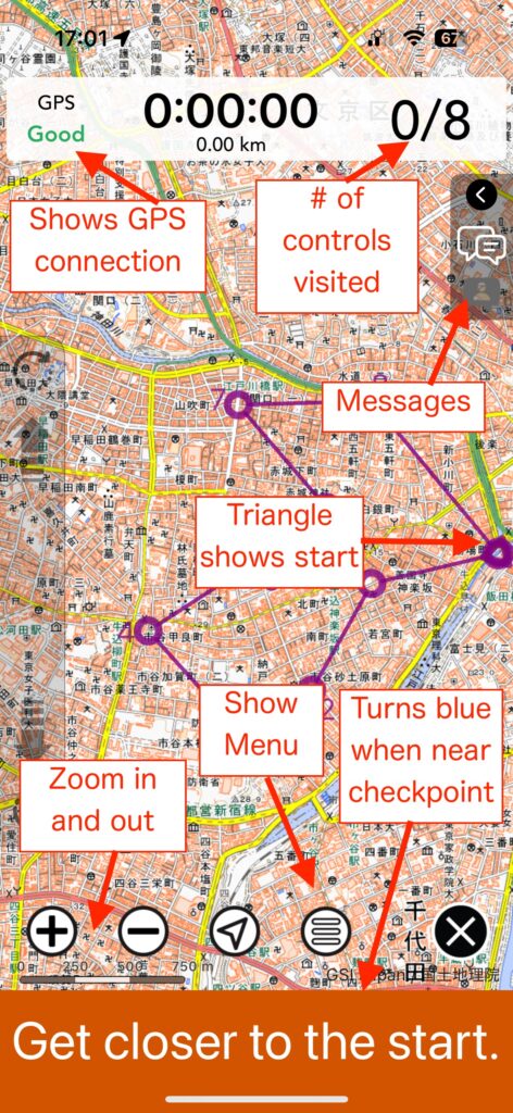
New Feature: Auto-Translation!
Have you traveled overseas, hoping to use NaviTabi but found that they are in the local language?
NaviTabi now has an automatic translation feature!
New Feature: Auto-Translation! Read More »
Have you traveled overseas, hoping to use NaviTabi but found that they are in the local language?
NaviTabi now has an automatic translation feature!
New Feature: Auto-Translation! Read More »
New feature on NaviTabi now allows you to have hidden check points on NaviTabi. If you want to add some randomness and surprises to make Rogaining fun for beginners or non-serious runners.
[New Feature] Secret Spots | Hidden checkpoints! Read More »
You can now analyze the results of Rogaining events using NaviTabi (※ As of January 2025, only the iOS version of the app is supported).
The result analysis function can be used by subscribing to the event organizer plan. Some functions can also be used for free.
Rogaining Data Analysis Function Read More »
You can now display vector shapes such as restricted areas (polygons) and routes (lines) on the app’s maps. *There are slight differences in the appearance of shapes between the iOS and Android versions.*The appearance of shapes also changes depending on the scale at which they are displayed. Importing shapes by event organizers If you sign
Showing Out of Bounds and Routes on the Map Read More »
Now you can NaviTabi with just one hand, with the shake function. When you arrive at a checkpoint and need to punch, instead of tapping the smartphone screen, you can shake to punch. This allows you to carry map in one hand and smartphone in the other much easier. Also, no need for the frustrations
The Shake! NaviTabi with just one hand! Read More »
NaviTabi User Event 2024 Spring was held on May 11th at Sudo Park, a small park middle of Tokyo. Despite the event being for just a few core users, we ended up with some new users from Norway who happened to be in Tokyo. Thanks for coming to the event! The score course running around
NaviTabi User Event 2024 Spring held with some international participants! Read More »
NaviTabi is known for making it easy to organize app based orienteering and rogaining events, but it is actually very good at making paper maps as well. Some of the recent updates have made map creating even more available for our users, so this is just a reminder for everyone what the app is capable
Powerful app functions for creating map files Read More »
NaviTabi App Update and OS Support Changes Thank you for your continuous support of NaviTabi. On April 5, 2024, we released an update to our app. This update also comes with changes to the operating systems we support. NaviTabi App Versions Supported OS Versions As a result of these changes, updates to the app will
App Update and Changes to Supported Operating Systems Announcement Read More »
Rogaining event organizers can now automatically generate maps and checkpoint lists using NaviTabi. Custom layouts, photo and text sizes for A3 to A4 formats are available. PDFs require an Organizer Plan for events, while personal users can download with the Player Plan. Free users can preview output. Feedback is welcomed at the Facebook group.
Automatically create map and checkpoint list as a PDF file! Read More »
NaviTabi app announces changes including a new “Player Plan” at 2.99 EUR monthly or 11.99 EUR yearly, offering unlimited access to detailed play records and downloadable maps. Free course play count method and access to past play records have been revised, with unlimited “Trial Courses” for Japanese users. Event Organizer Plan price is cut to 49.99 EUR annually. Additional in-app purchase options are now available for expanding play counts in Japan.
New subscription plan for individuals and new plan pricing for organizers! Read More »